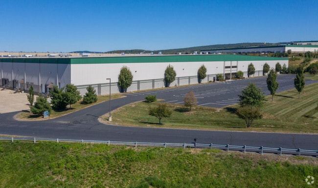
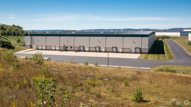
Property Record
Capital Rd, Pittston, PA 18640

NEARBY LISTINGS FOR SALE OR LEASE
Property Detail
Capital Rd
Scranton--Wilkes-Barre--Hazelton, PA
Centerpoint East Commerce & Trade Park
33-F12-00A-16S-000
14.87 ACRES
Warehouse
Luzerne
X
Pennsylvania
42079C0242E
16s
2025
14.61 AC
2025
I-81 Corridor
211701
Philadelphia
DEMOGRAPHICS near Capital Rd
1 Mile
3 Mile
5 Mile
2024 Total Population
216
20,639
58,234
2029 Population
216
20,616
57,895
Pop Growth 2024-2029
0.00%
(0.11%)
(0.58%)
Average Age
45
44
44
2024 Total Households
81
9,172
26,115
HH Growth 2024-2029
0.00%
(0.14%)
(0.61%)
Median Household Inc
$80,769
$61,115
$65,398
Avg Household Size
2.60
2.20
2.20
2024 Avg HH Vehicles
2.00
2.00
2.00
Median Home Value
$99,999
$143,876
$147,350
Median Year Built
1975
1949
1954
Nearby Places
Map Layers
Map Styles
 Street
 Aerial
- Restaurants
- Banks
- Shops
- Fitness
- Groceries
PUBLIC TRANSPORTATION
AIRPORT
Wilkes-Barre/Scranton International
DRIVE
WALK
Distance
Wilkes-Barre/Scranton International
14 min
4.4 mi
SALE & LEASE HISTORY
LISTING DATE
SALE/LEASE

Jun 11, 2019
For Lease
Nearby Properties
Address
Land Use
TOTAL SIZE
Lot Size
Zoning
Address
Land Use
TOTAL SIZE
Lot Size
Zoning
225.55 AC
Address
Land Use
TOTAL SIZE
Lot Size
Zoning
48.95 AC
Address
Land Use
TOTAL SIZE
Lot Size
Zoning
46.26 AC
Address
Land Use
TOTAL SIZE
Lot Size
Zoning
Address
Land Use
TOTAL SIZE
Lot Size
Zoning
130.63 AC
Address
Land Use
TOTAL SIZE
Lot Size
Zoning
92.99 AC
Address
Land Use
TOTAL SIZE
Lot Size
Zoning
59.28 AC
Address
Land Use
TOTAL SIZE
Lot Size
Zoning
58.45 AC
Address
Land Use
TOTAL SIZE
Lot Size
Zoning
46.01 AC
Address
Land Use
TOTAL SIZE
Lot Size
Zoning
51.15 AC
Address
Land Use
TOTAL SIZE
Lot Size
Zoning
43.65 AC
Address
Land Use
TOTAL SIZE
Lot Size
Zoning
50.85 AC
Address
Land Use
TOTAL SIZE
Lot Size
Zoning
67.25 AC
Address
Land Use
TOTAL SIZE
Lot Size
Zoning
46.47 AC
Address
Land Use
TOTAL SIZE
Lot Size
Zoning
42.72 AC
Address
Land Use
TOTAL SIZE
Lot Size
Zoning
24.33 AC
Address
Land Use
TOTAL SIZE
Lot Size
Zoning
34.07 AC
Address
Land Use
TOTAL SIZE
Lot Size
Zoning
15.60 AC
Address
Land Use
TOTAL SIZE
Lot Size
Zoning
28.06 AC
Address
Land Use
TOTAL SIZE
Lot Size
Zoning
27.12 AC
Address
Land Use
TOTAL SIZE
Lot Size
Zoning
24.30 AC
Address
Land Use
TOTAL SIZE
Lot Size
Zoning
21.31 AC
Address
Land Use
TOTAL SIZE
Lot Size
Zoning
5.93 AC
Address
Land Use
TOTAL SIZE
Lot Size
Zoning
13.59 AC
Address
Land Use
TOTAL SIZE
Lot Size
Zoning
14.35 AC
Address
Land Use
TOTAL SIZE
Lot Size
Zoning
4.56 AC
Address
Land Use
TOTAL SIZE
Lot Size
Zoning
9.70 AC
Address
Land Use
TOTAL SIZE
Lot Size
Zoning
Address
Land Use
TOTAL SIZE
Lot Size
Zoning
21.81 AC
The World's #1 Commercial Real Estate Marketplace
Connect with us
© 2026 CoStar Group
The information above has been obtained from sources believed reliable. While we do not doubt its accuracy we have not verified it and make no guarantee, warranty or representation about it. It is your responsibility to independently confirm its accuracy and completeness. Any projections, opinions, assumptions, or estimates used are for example only and do not represent the current or future performance of the property. The value of this transaction to you depends on tax and other factors which should be evaluated by your tax, financial, and legal advisors. You and your advisors should conduct a careful, independent investigation of the property to determine to your satisfaction the suitability of the property for your needs.